This solution participated in a Driver+ Trial

Provider(s):

You must log in in order to see contact information. If you don't have an account, you can ask for one on this form.
This humanitarian ICT solution, geoBingAn, provides the SaaS platform of emergency operation center (EOC) for developing area

geoBingAn (pronounced Geo-Bing-An) is Taiwanese language, means “wish you all the best, safe and sound”. This innovative ICT is developed by GeoThings, allows the users to collect various sorts of data for pre- survey, in- , and post-disaster . This geoBingAn works for the field surveyors just as easy as if they were using Google Forms with OpenStreetMap features on mobile, which enable the survey activity to directly interact with basemap and immediately presented on GIS (Geospatial Information System) for later statistics. The SituationDesk of geoBingAn provides the column-based filtering in to the over-whelming incoming information during special event or .

This leveraged international open standards for the integration of crowdsourcing and IoT sensor data. With OpenStreetMap as basemap, all the visualization and statistics are much clear and easier to be presented on geoBingAn 3D GIS-based platform.

The geoBingAn service has adopted in the technical assistant project for the capacity building to disaster by Asian Development Bank, also selected by Beyond Europe project, QuinJunSAT, by Austrian Research Promotion Agency (FFG). This service is available to the communities, NGOs, NPOs, private sectors, and government agencies. now even extended for urban planning and smart city scenarios for a better sustainable tomorrow.

Supported Use Cases

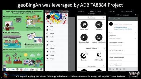
geoBingAn for Asian Development Bank Technical Assistant No.8884
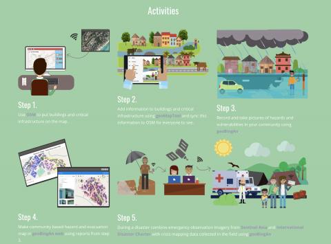
The ADB TA8884 project aims to assist piloting countries to improve local capacity to collect and share reliable and timely -related data using geoBingA as ICT  at a local government and community level in a more cost-effective manner to strengthen their and support timely post-disaster , , and reconstruction efforts. With the support of humanitarian ICT, geoBingAn, the following activities are carried out: i) Develop a mobile application for preparing community-based OSM base map; ii) Develop a mobile application to collect attribute data for buildings and critical infrastructures; iii) Carry our mapping; iv) Utilize satellite data for damage , v) Develop a data server and data management system at local governments.

Related CM functions

How ICT can support in the preparedness and response to disaster
geoBingAn as the humanitarian ICT for Asian Development Bank TA8884 project

QuinJunSAT, a Beyond Europe project
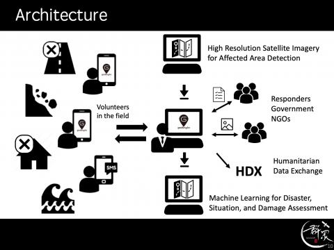
QuinJunSAT, “Improved Situational Awareness during Events through Integration of Crowdsourced Data with EO Derived Information”, is an international project providing services in the domain of Crisis and Management, which combine Earth and Crowdsourcing technologies. The project is funded by the Austrian Research Promotion Agency (FFG), which is the national funding agency for industrial research and development in Austria.

The aim of the experimental development project is to integrate the key technological expertise of the involved Austrian (Earth , Information System and Crowdtasking Technologies), and Taiwanese (Social media  and Crowdsourcing technologies) consortium partners through dedicated mutual development [and demonstration] activities, thereby providing a technology leap and increased competitiveness for the Austrian partners to serve the European and international development, as well as the management sector.

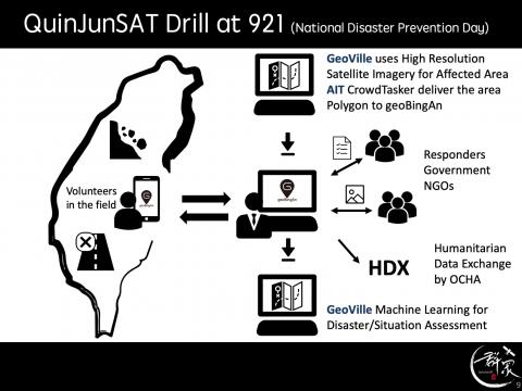
Specifically, QuinJunSAT (QuinJun, 群眾, is the pronunciation of the word “crowd” in traditional Chinese) shall improve the capacity of crisis managers before, during and after events through an innovative approach, in which satellite and crowdsourced information from volunteers are automatically integrated to obtain quick and accurate information of damages.

Key information on damaged infrastructure is extracted from very high-resolution satellite imagery in an automatic way, while the data provided by volunteers through a smartphone application will confirm or reject the  detected damages, as well as provide additional data of potential relevance for crisis managers. By combining earth observation (EO) data with information obtained from crowdsourcing, we aim at improving the existing situational awareness picture by drastically increasing the detection and identification accuracy of damaged infrastructure, which will lead to:

  • smarter resource allocation and actions
  • shorter reaction times and
  • lower total costs for relief actions.

The integrative technological components to fulfil the above mentioned aims will be validated and tested with volunteers in Taiwan during the National Disaster Day and benchmarked as baseline for marketing in Asia, Europe and worldwide.


Related CM functions

QuinJunSAT deployment for Taiwan National Disaster Prevention Day, September 21st, 2018
Information flow and Architecture of QuinJunSAT
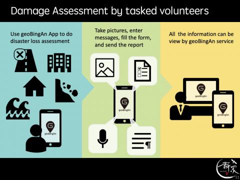
Damage Assessment by Tasked Volunteers using geoBingAn

Strengthening the Disaster Resilience with ICT based EOC, geoBingAn PacWave2018 and World Tsunami Awareness Day 2019 as Practice
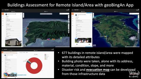
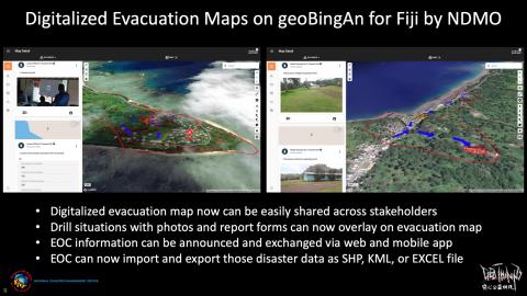
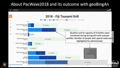
The geoBingAn app was introduced for the first time in an in Fiji on 1 March 2018 by the country’s National Management Office (NDMO) during a tsunami drill. About 730 evacuees in PacWave2018 and more than 1700 students, including those from Fiji School for Blind, in World Tsunami Awareness Day 2019, were safely guided and efficiently evacuated because of the proper situation coordination with geoBingAn.

The drill provided management officials with real-time information on a simulated - from the issuance of the public advisory to the safe arrival of people at the evacuation sites. The NDMO said that the was an indication of Fiji’s plans to move towards space-based technology and Information Communication Technology (ICT) to assist in emergencies.

For the capacity building of disaster in to Tsunami, geoBingAn serves great and demonstrated how ICT can work for humanity. With this ICT-based EOC, geoBingAn, for Fiji NDMO, now:

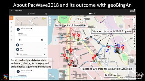
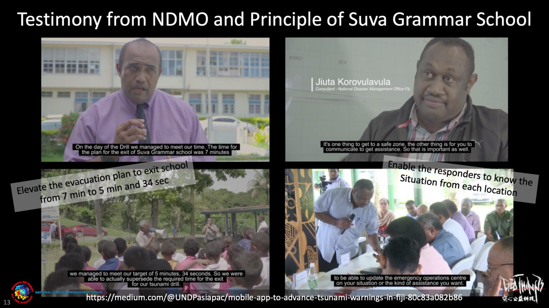
–elevate the evacuation plan to exit Suva Grammar School from 7 min to 5 min and 34 sec

–is empowered to know the Situation with its location and status

–can deliver better communication and coordination to the responders from NEOC

–can plan and publish the evacuation map for both web and mobile app access

–can administrate, time, and review the drill progress from its beginning to the end.

Related CM functions

Buildings Assessment for Remote Island/Area with geoBingAn App
Digitalized Evacuation Maps on geoBingAn for Fiji by NDMO
About PacWave2018 and its outcome with geoBingAn for Evacuation Route
About PacWave2018 and its outcome with geoBingAn for Shelter Management Status
Illustrations
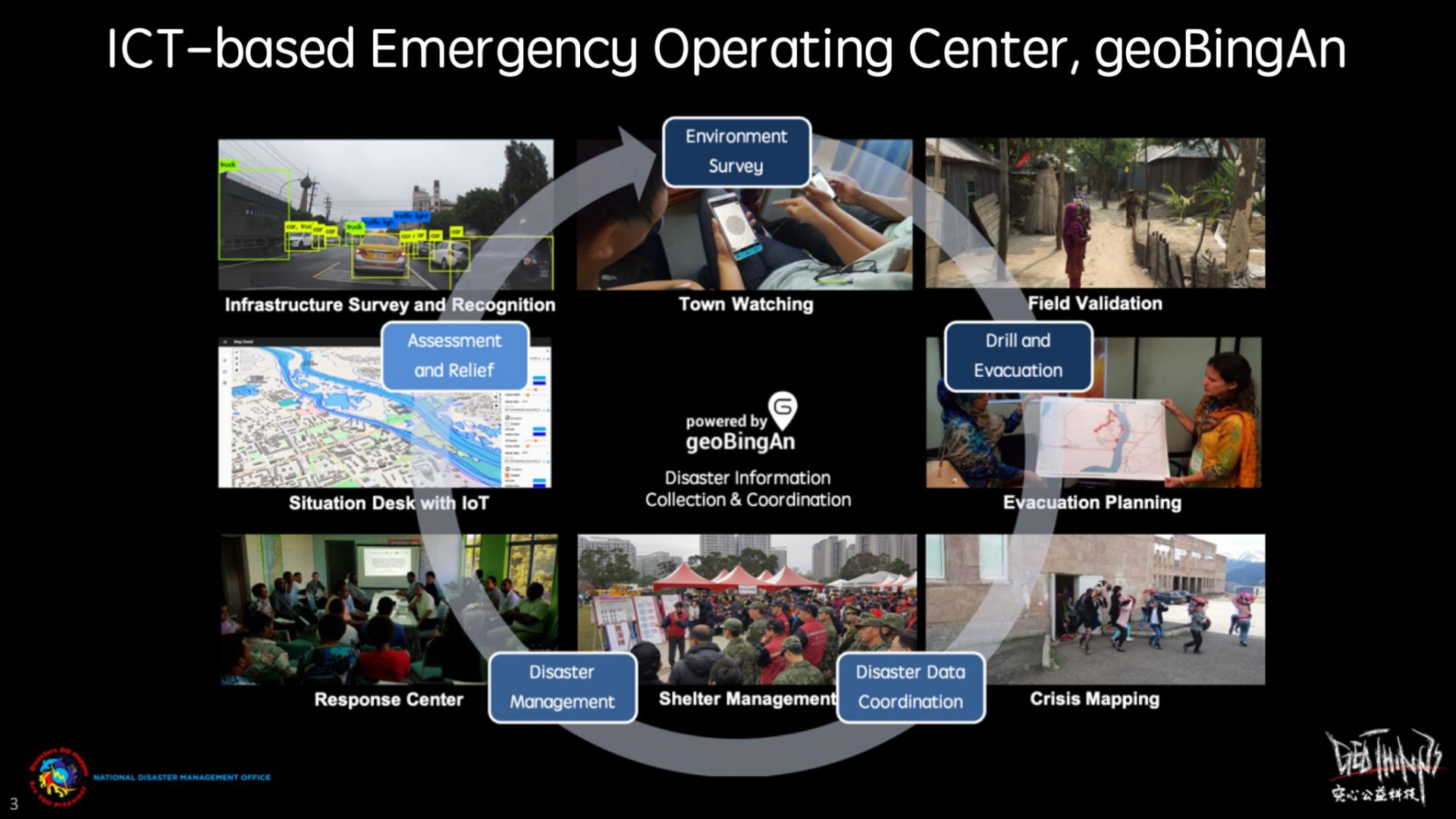
The humanitarian ICT, geoBingAn, is an integrated service that works for pre-/in-/post-disaster response
Testimony from NDMO and Principle of Suva Grammar School using geoBingAn
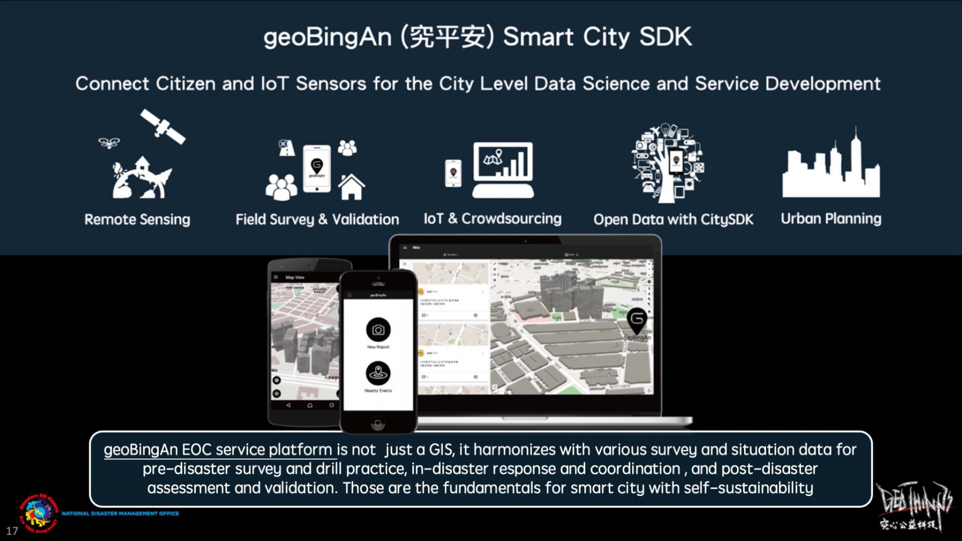
geoBingAn can be not only the EOC, but also the Smart City Service Development Kit platform for urban planning!
  • 0
  • 1
  • 2
eu Portfolio of Solutions web site has been initially developed in the scope of DRIVER+ project. Today, the service is managed by AIT Austrian Institute of Technology GmbH., for the benefit of the European Management. PoS is endorsed and supported by the Disaster Competence Network Austria (DCNA) as well as by the STAMINA and TeamAware H2020 projects.