Real-time location of responders and hazards
Endorsed by
Motivation
The ability to know the location of responders and their proximity to risks/threats and hazards in real time
Potential Solutions
Following solutions could be addressing this gap.
Across IFAFRI member nations, first responders consistently stated that there is a
to precisely identify the location of responders in real time. Further, commanders expressed a
for a
that displays the location of responders and their proximity to potential threats. The ability to geolocate first responders in all environments, especially when coupled With simultaneous awareness of incident risks and hazards and responder distress, could potentially improve the safety, efficiency, and effectiveness of
operations.
Addressing this involves the development of tools that capture the precise location of responders (i.e., x, y, and z coordinates) indoors, outdoors, and below ground, and the graphical display of the location on an intuitive user interface. It further involves the identification and display of threats and hazards in proximity to on scene responders when integrated With sensors and other detection systems.
This is largely unavailable to date. Current capabilities are limited to visual tracking of responders and self-report of location using hand-held radios. Some public safety radio systems include global positioning system (GPS) reporting of location, but infrastructure and network requirements constrain the use of this feature. Commercially available GPS signals cannot penetrate building walls and are not ruggedized for the hazards on an incident scene.
A robust and flexible capability is needed to help commanders and tactical decision makers accurately locate and track first responders anywhere on the incident scene. This capability is also necessary to allow them to rapidly and effectively direct rescue missions for at-risk personnel, as well as understand and respond to the consequences of potential threats to responders in real time.
Rationale & related CM function(s)
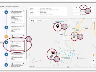
Accurate, real-time three-dimensional location of first responders on the incident scene.
Graphical display of first responder location and tracking information on an incident-specific geospatial map for commanders
Situational awareness systems and data sources
- Integrate data collection tools
- Manage data
- Set-up data storage and retrieval
- Enhance education, awareness and skills on mitigation measures
- Maintain population's operational awareness
- Maintain public awareness on hazards and respective services
- Maintain shared situational awareness
- Provide predictive analysis and situational awareness
- Provide situational awareness, share COP
- Raise awareness and anticipate
 |
Portfolio of Solutions web site has been initially developed in the scope of DRIVER+ project. Today, the service is managed by AIT Austrian Institute of Technology GmbH., for the benefit of the European Management. PoS is endorsed and supported by the Disaster Competence Network Austria (DCNA) as well as by the STAMINA and TeamAware H2020 projects. |