Contact
Provider(s):
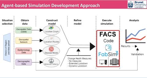
FACS is an agent-based modelling code that models the spread of flu and coronaviruses in local regions. Up to now, we have used it to model the spread of Covid-19 in a range of London boroughs.
The code can be repurposed to model other regions, and its current (sequential) implementation should be able to run up to 500,000 households within a reasonable time frame. It also supports vaccination programmes, track and trace and mutated versions of the virus.
What sets FACS apart from many other codes is that we have a partially automated location extraction approach from OpenStreetMaps data (the scripts reside at https://www.github.com/djgroen/covid19-preprocess), that we resolve a wide range of different location types (e.g., supermarkets, offices, parks, schools, leisure locations and hospitals) and that we have a specific algorithm for modeling infections within these locations, taking into account the physical size of each location.
We are currently finalizing a first journal paper about FACS, and will link to it from this page once it has become available.
Supported Use Cases
Agent based modelling tool to simulate spread of pathogens
 |
Il sito web Portfolio of Solutions è stato inizialmente sviluppato nell'ambito del progetto DRIVER+. Oggi, il servizio è gestito da AIT Austrian Institute of Technology GmbH, a beneficio della gestione europea delle . PoS è approvato e supportato dal Disaster Competence Network Austria (DCNA) così come dai progetti STAMINA e TeamAware H2020. |


