Contact
Provider(s):
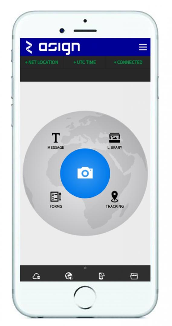
It is an optimal all-in-one software for the collection, communication and management of operationally relevant information. ASIGN supports the collection and communication of photos, videos, geo-texts, tracks and forms in a very bandwidth efficient manner. Specifically, it can communicate photos and video with 99% bandwidth reduction, enabling communication even through low bandwidth cellular and mobile satellite communication networks while maintaining full precision and accuracy.
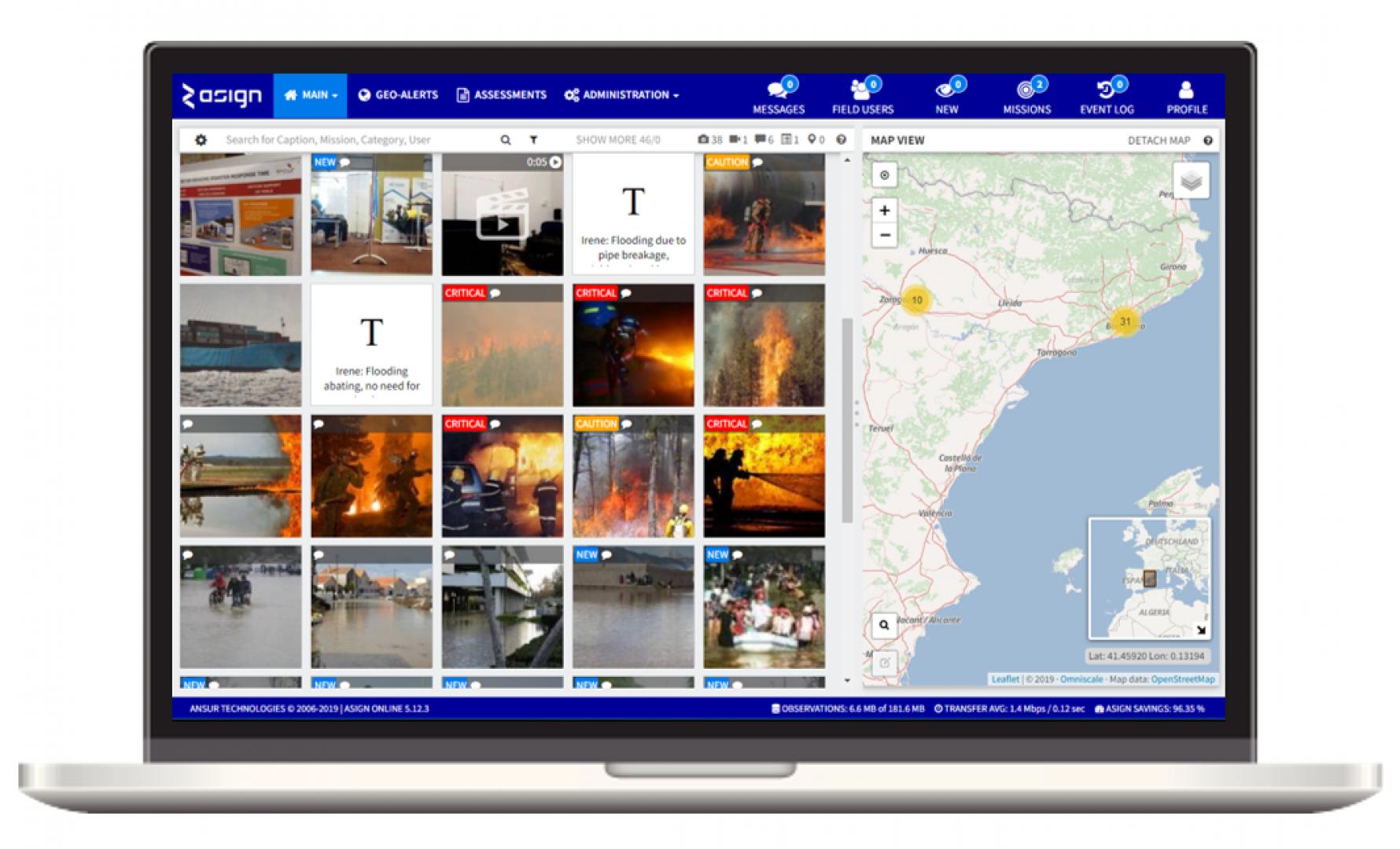
ASIGN is comprised of the ASIGN Server, a cloud-based platform from which the incoming information is managed, plus the field user applications ASIGN PRO and UAV-ASIGN, which collect and send information from the field to the Server, all with end-to-end encryption. Photos and videos sent through the ASIGN field user applications arrive up to 100x faster at their destination, enabling a better-informed and swifter decision-making process and subsequent action.
The main ASIGN PRO and ASIGN Server capabilities include:
- Reliable communication of highest precision geo-spatial photo and video content even in low-bandwidth situations.
- 'Details by demand' methodology allows for full-precision data while focusing network resources on sending operationally relevant content.
- Professional camera and 360 video camera integration.
- Increased field team coordination through ‘live mission stream’ function, enabling team members to view what their team members are contributing.
- Tracking function and geo-zone alert abilities for increased coordination and user safety
- The creation and dissemination of customized Assessment Forms and collaborative reports, as well as the exporting of the collected data
- A common operational picture, with a powerful backend system with user / mission management capabilities.
- Classification and categorisation capabilities for better data management and analysis
ASIGN’s functions have been specifically developed to target the speed and efficiency of time-critical data collection, communication and development of situational understanding in order to reduce and time.
Supported Use Cases
Disaster Assessment Tool
Reducing response time through efficient data collection, communication and situational understanding
References
United Nations Disaster Management
AnsuR has been working successfully with the UN over 10 years to create and evolve the ASIGN software suite, an optimal all-in-one software , for collection, communication and management of operationally relevant information. ASIGN is an official UN Information Management and has been used by the UN to help make better decisions faster, specifically in the critical first days following a .
UN ASIGN Crowdsourcing has been used with UNOSAT for crowdsourcing and by volunteers in the field for the collection of in-situ geo-referenced photographs and data that is combined with information from satellite earth . ASIGN observations give an in-situ view of the situation and can complemented Satellite Imagery for better overall situational awareness and . Imagery collected through ASIGN has been previously integrated into GDACS LIVE Map provided by UNITAR and UNOSAT. ASIGN has been used in several crisis in both Asia and South America, notably for the Flooding in Thailand in 2011 and the Nepal Earthquake in 2015.
INSARAG has selected ASIGN PRO as a field assessment tool for all kinds of visual field information collection and communication due to the bandwidth efficiency of the ASIGN solutions. INSARAG has the responsibility of facilitating the coordination of search & rescue teams and fast in the context of earthquakes and other major disasters. As infrastructure is often extensively damaged in situations, the problem INSARAG has been facing in situations is unreliable networks and problem with the fast and reliable communication of high precision photographs and video clips. The ASIGN software solves this issue by enabling INSARAG members to send images, videos and assessment forms efficiently through limited networks and satellite communication.
Police and Security Forces
The ASIGN software has been purchased by Norwegian and Danish police forces for security and surveillance purposes. In this case, the typical field application combines the AISGN PRO application, which allows users to import files from external camera sources, with the professional DSLR cameras for high-precision photography. When the photographs captured have a very high definition, image files tend to increase correspondingly and then users quite frequently encounter situations where there simply is insufficient bandwidth to communicate the photos, unless ASIGN is used. The pictures communicated through ASIGN PRO are geo-referenced and combined with other information are shown in a common operation mapping portal, the ASIGN Server. Tracking functions and the ability to import photos from the phone photo album are additional features that the police are actively using.
The live mission stream , which allows participants within the same mission could share their observations and view their colleagues’ contributions, was specifically developed at the request of the police. Each police officer can work on multiple missions as needed and can move themselves among the missions they are allocated to, choosing with whom the photos and videos they collect should be shared with. The using the ASIGN Server can also allocate the field users to specific missions.
Security and encryption measures of the software were also highlighted as key aspects of ASIGN that made it a suitable for police operations. For example, the photographs that are taken through the ASIGN application on s smartphone cannot be found by connecting the phone to a computer. This is important in cases when phones are lost and may contain sensitive information. The ASIGN server service is furthermore hosted by the police force itself, so that they have private ownership of all the collected data.
BNPB – Indonesian Board for Disaster Management
Almost every year, Indonesia experienced a natural which damages local terrestrial and mobile networks to such an extent that they become unstable or entirely stop working. As a result, visual situational imagery and information required for the of damage and time-critical decision making could not be communicated out of the field.
The Indonesian Board for Management (known as the BNPB – Badan Nasionala Penanggulangan Bencana), responsible for preparing for and managing the country’s disaster , chose AnsuR’s ASIGN to overcome this issue. ASIGN is now being used to effectively communicate key information through Inmarsat satellite communication. This enables the pre-deployment of an communications infrastructure, supporting the country’s disaster in the event of a natural catastrophe.
DRIVER+ Trial 3 in Austria
The ASIGN field user application and central server were used in two scenarios within the . As part of the Chemical Spill , ASIGN PRO was used to take and communicate Geo-tagged photos from the field, indicating the presence of a chemical spill. In the control room, a 'danger zone' was placed around the designated Chemical Spill area. This area was sent to the tested and was shown on VieWTerra and also in CrowdTasker. ASIGN PRO was used to communicate further observations from the field and could be shown on the ASIGN Server as well as on VieWTerra. Messages were sent back and forth using the ASIGN suite to communicate between the control center and field users. For the USAR , ASIGN PRO was used to track users throughout the . Initially, user displaced themselves to a location with no 3G/4G connectivity to simulate a scenario where the conventional communication channels are down. Users were able to communicate through by connecting to a portable satellite terminal, a BGAN, and through ASIGN PRO reliably sent out photos and videos through satellite communication. Moving on to a second location, 360 photos and videos were also sent from the field to give a full view of the situation.

Documentation
Similar Solutions
 |
Portfolio of Solutions web site has been initially developed in the scope of DRIVER+ project. Today, the service is managed by AIT Austrian Institute of Technology GmbH., for the benefit of the European Management. PoS is endorsed and supported by the Disaster Competence Network Austria (DCNA) as well as by the STAMINA and TeamAware H2020 projects. |