Provider(s):

You must log in in order to see contact information. If you don't have an account, you can ask for one on this form.
Zirkarta gets the right information to the right people at the right time to enable geographically dispersed people to work together to achieve a common objective during a crisis.


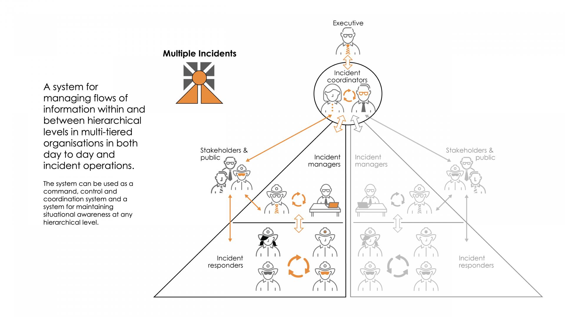
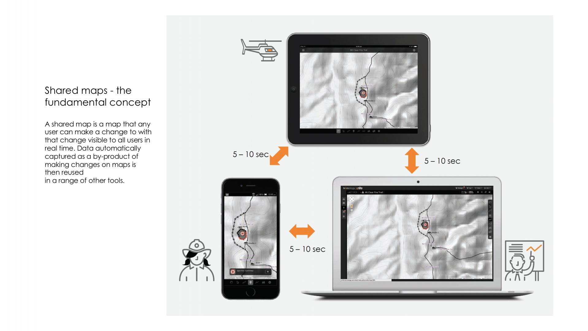
Zirkarta is a platform that enables managers to build their own systems for sharing map-related information between geographically separated users, in the field and the office, in real-time, without writing a single line of computer code.

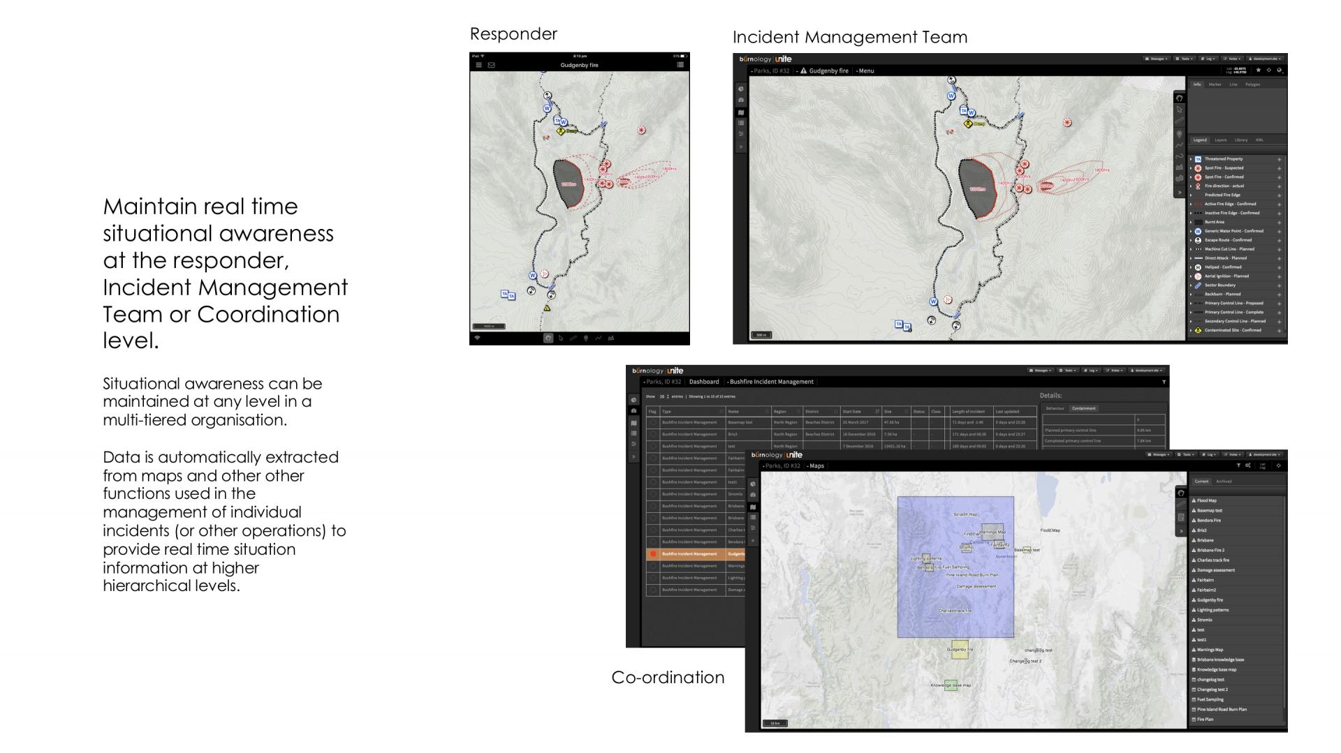
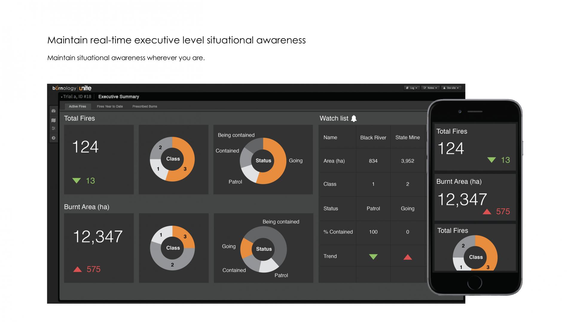
Pre-defined data is automatically shared with stakeholders, represented for a range of hierarchical levels and used in analytics tools including automatically generating plans, reports and dashboards – all in real-time.

Uniquely, it enables crisis managers and responders to obtain shared situational awareness on any device wherever they are, including before they even arrive.

It does not require the installation of any software (even for offline use) and works on any fixed or mobile device using any operating system.

Supported Use Cases

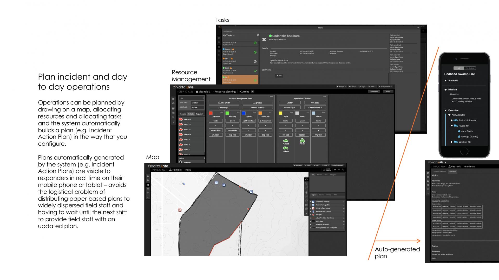
Build and distribute plans

  1. Planner draws features on the map illustrating the planned activities (these could relate to any spatial operation including , incident or ).
  2. Planner allocates tasks.
  3. Planner plans human and equipment resources.
  4. System builds populated plan based on pre-configured template based on plotted map features, tasks, people and equipment allocations and spreadsheet like calculations.
  5. Planner completes manual data entry fields in plan form.
  6. System distributes populated plan to all users on mobile, fixed and laptop devices.
  7. System automatically updates and redistributes plan as data on map is changed, tasks are implemented, the allocation of human and equipment resources is changed and the planner changes data in manual data entry fields.

Related CM functions

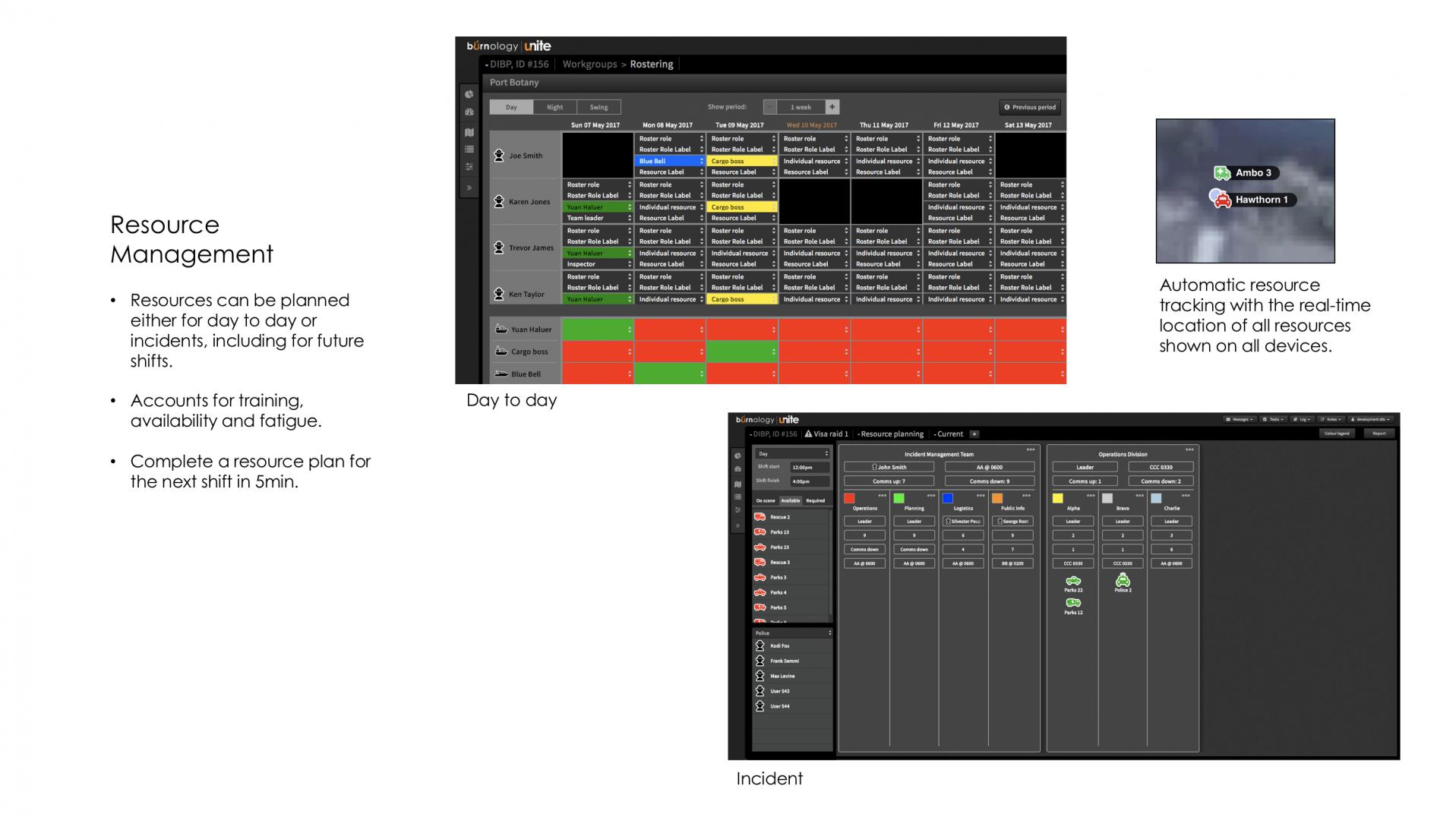
Plan human resources and equipment

  1. Individual user specifies the days/shifts they are available.
  2. Planner builds organisational structure for managing the incident/implementing the plan.
  3. Planner specifies communication arrangements for each part of the organisational structure.
  4. Using drag and drop, the planner allocates equipment to the organisational structure.
  5. System filters available human resources based on individual availability, the fatigue management criteria of the person, the /competencies of the individual and the /competencies required to operate the equipment type.
  6. Planner allocates users from the filtered list to specific pieces of equipment using drag and drop.

Related CM functions

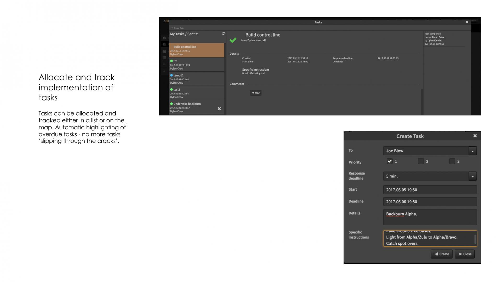
Allocate and track tasks

  1. Manager creates task, either in a list or by attaching it to a feature on a map, and specifies who will implement the task.
  2. System makes the task visible to the task recipient.
  3. Task recipient accepts the task.
  4. Task recipient identifies the task as complete either in a list or by changing the linked mapped feature to complete.
  5. If the task is not completed by the specified deadline, system identifies the task as overdue to the manager who created the task and the user specified to complete the task.

Related CM functions

Share information between field responders and managers

  1. Ground or aerial based field responder change to map (plots a new feature, changes an existing feature, deletes an existing feature, attaches a document – including a photo - to a feature) on mobile device or manager makes change to map on fixed/laptop device. Map features may relate to physical features, planned activities or threats to safety.
  2. System makes changes visible on the shared map.
  3. Change visible to all field responders on mobile devices and managers on fixed/laptop devices within seconds.

Related CM functions

Track real time resource locations

  1. Ground or aerial based field responder specifies the icon, icon colour and label their current location will be visible to other users.
  2. System makes the location of the user visible on the shared map symbolised and labelled as specified by the field responder.
  3. The current location of all users is visible to all actors on all mobile, fixed and laptop devices.

Related CM functions

Provide statistical/summary information on multiple simultaneous incidents/plans to co-ordinators and executives

  1. Ground or aerial based field responder makes change to map (plots a new feature, changes an existing feature, deletes an existing feature) on mobile device or manager makes change to map on fixed/laptop device. Map features may relate to physical features, planned activities or threats to safety.
  2. System uses data from the map to calculate pre-defined statistics.
  3. Coordinator or executive views statistical/summary information from multiple simultaneous plans/incidents in a dashboard on fixed/laptop device.
  4. Coordinator/executive filters and/or drills in for more detail on the dashboard.
  5. Coordinator/executive views high level summary data in the executive summary on any mobile, fixed or laptop device.
  6. System adds shared map to overview map.
  7. Coordinator/executive views the location of individual plans/incidents on an overview map on desktop/laptop devices.

Related CM functions

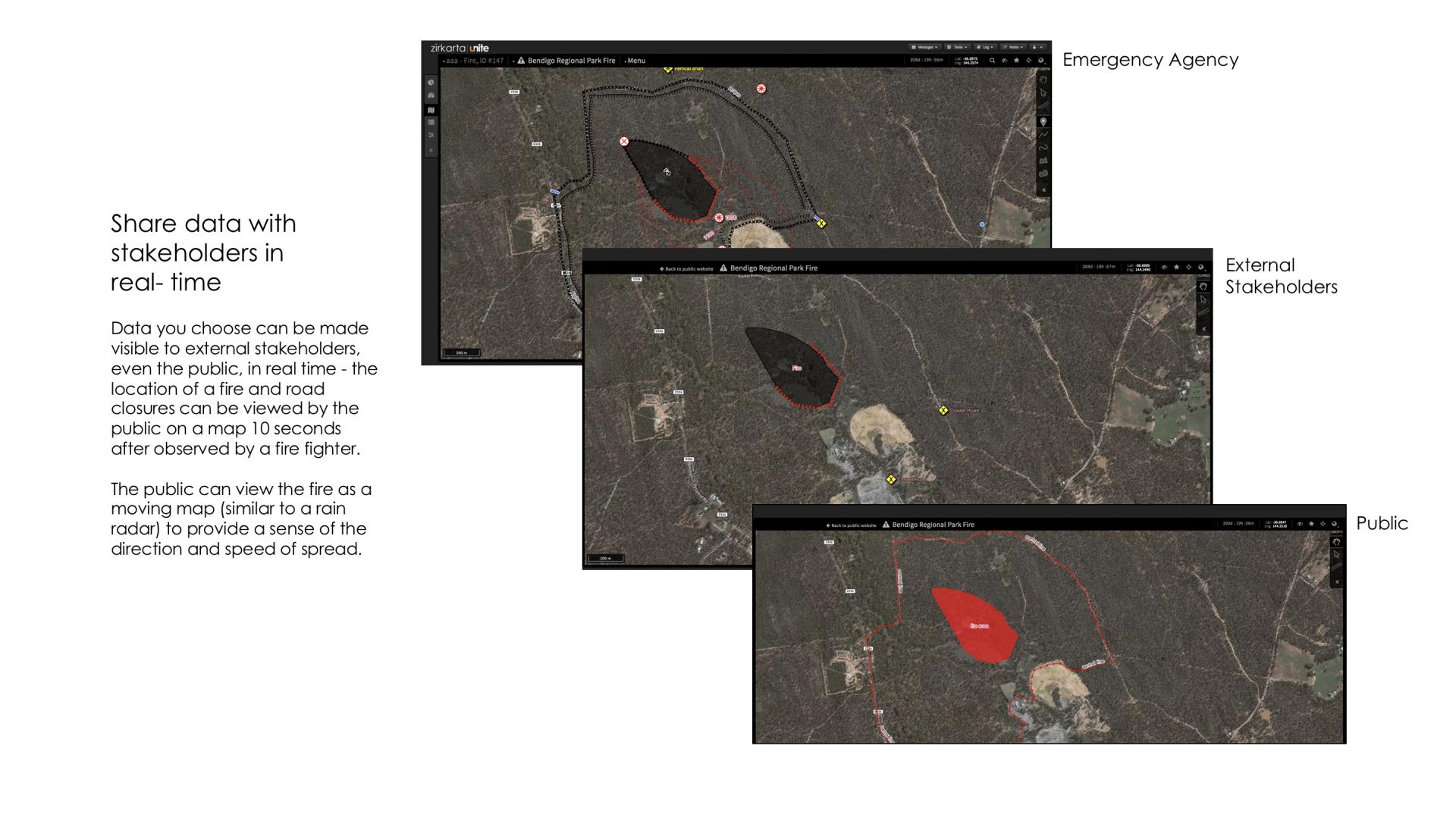
Share information with stakeholders and the public

  1. Ground or aerial based field responder makes change to map (plots a new feature, changes an existing feature, deletes an existing feature) on mobile device or manager makes change to map on fixed/laptop device. Changes can relate to the status of the plan/incident, actions being undertaken to combat the incident, threats to safety and evacuation and sheltering.
  2. In accordance with a pre-configured template, system makes specified information changed by field responders and managers visible on a public facing web site.
  3. Stakeholders/the public view the information on the public facing web site.

Related CM functions

Illustrations
Role of System
Shared Maps
Multi level situational awareness
Executive summary
Resource management
Tasking
Auto populated plans
Spatial learning
Public and stakeholder information
Accountability
Configuration
  • 0
  • 1
  • 2
  • 3
  • 4
  • 5
  • 6
  • 7
  • 8
  • 9
  • 10
Video illustrations
eu Portfolio of Solutions web site has been initially developed in the scope of DRIVER+ project. Today, the service is managed by AIT Austrian Institute of Technology GmbH., for the benefit of the European Management. PoS is endorsed and supported by the Disaster Competence Network Austria (DCNA) as well as by the STAMINA and TeamAware H2020 projects.